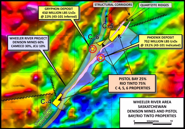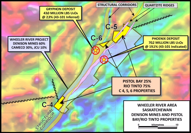

Rio Tinto Canada Uranium Corp / Rio Tinto Exploration Canada Inc. (RTCCU / RTCCI or Rio Tinto) has an ongoing exploration program on the 2500 acre (1016 hectares) C-5 Uranium property in the Athabasca Basin, Northern Saskatchewan. The C-5 property lies 5 kilometers north of the Phoenix Uranium deposit controlled by Denison Mines Corp.
The C5 property, together with the C4 and C6 claims, is under option to Rio Tinto, which has earned a 75% interest, and has previously announced its intention to exercise the further option to acquire 100% interest by paying Pistol Bay C$5,000,000 within 5 years of December 31st, 2014 and granting Pistol Bay a 5 percent net profits interest (see Pistol Bay news release of February 16th, 2015). Rio Tinto has, to date, completed 12 diamond drill holes totalling 6,104 metres on the C5 property and carried out a gravity survey. The 2015 program commenced in late October. It consists of a DC resistivity survey and is being conducted by Discovery Geophysics of Saskatoon and Vancouver.
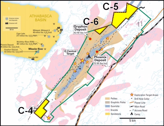
Uranium mineralization in the Athabasca Basin is spatially associated with the unconformity where the Athabasca sandstones rest on top of older basement rocks. The unconformity is approximately 400 metres below surface in the area of the C4, C5 and C6 properties. The highlight of Rio Tinto’s program on C5 so far was the intersection in diamond drill hole 14CBK003 of 1.08 pounds per ton U3O8 (460 ppm U = 0.054% U3O8) over a core length of 1.5 metres, including 1.42 pounds per ton U3O8 (606 ppm U = 0.071% U3O8) over 0.5 metre.
Core recovery was approximately 50 percent, indicating that the assay does not accurately reflect the uranium content of the rock. In addition, diamond drill hole 14CBK0005, 50 metres to the northeast of 14CBK003, intersected 0.82 pounds per ton U3O8 (346 ppm U = 0.041% U3O8) across a core length of 0.32 metres just below the unconformity, and 0.44 pounds per ton (184 ppm U = 0.022% U3O8) across a core length of 1.00 metre, 5 metres below the unconformity. These results were previously disclosed in a Pistol Bay news release on June 4th, 2014. The C4, C5 and C6 properties adjoin the 11,720 hectare Wheeler River property of Denison Mines Corp. (60%), Cameco Corp. (30%) and J CU (Canada) Exploration Co. (10%). Wheeler River includes the newly (2008) discovered Phoenix Zone, with an indicated mineral resource of 70,200,000 pounds of U3O8 grading 19.13% plus an inferred mineral resource of 1,100,000 pounds of U3O8 at a grade of 5.80%. The Phoenix Zone is 5 kilometres south of the C5 claim and less than 3 kilometres from the boundary of C6 (Denison Mines Corp. annual report 2014).
The C4, C5 and C6 properties are situated approximately mid-way between the former producing Key Lake mine and the currently producing McArthur River Mine of Cameco Corp. (70%) and AREVA (30%). McArthur River has produced, to the end of September 2015, a total of 283.3 million pounds of U3O8. It has reserves of 345.2 million pounds at 14.87% U3O8, measured plus indicated mineral resources of 10.6 million pounds at 4.24% U3O8 and an inferred mineral resource of\ 57.2 million pounds. With a total endowment of almost 700 million pounds, McArthur River is the largest high grade uranium mine in the world (Cameco Corp. annual and quarterly reports).
The C4, C5 and C6 properties are road-accessible, an important feature that allows exploration funds to be used much more effectively than more remote, fly-in projects. The 75-kilometre all-weather haul road from the McArthur River mine to Cameco’s Key Lake mine/mill passes approximately 5 kilometres from the properties, and there is a network of bush roads or trails that can be used by 4-wheel drive vehicles.
The information in this news release has been prepared and/or reviewed by Colin Bowdidge, Ph.D., P.Geo., a Qualified Person as defined in National Instrument 43-101. Uranium analyses quoted in this news release were performed for Rio Tinto by SRC Geoanalytical Laboratories in Saskatoon, using ICP-mass spectrometry. The geometry of the mineralized intervals quoted here is not known, and no estimate of true widths has been made.